Welcome to BigEyeInTheSky.com
I'm Ed Fink, these are my 360 degree panoramas. I was the first photographer in the world to shoot 360 degree panoramas from a helicopter. Today I'm a FAA licensed drone pilot and shoot most of my aerials with a quadcopter.
In addition to shooting aerial panoramas, I'm also a Google Street View Trusted Photographer in Minneapolis shooting Street View tours inside local businesses.
I publish thousands of 360 degree panoramas and virtual tours to Google Maps, where I currently have over 100 MILLION VIEWS.
Ask me for more information or an estimate for your business!
Facebook - BigEyeInTheSky360
Google Maps - Ed Fink

VISITOR COMMENTS:
"That's the coolest thing on the web."
"You brought tears to my eyes."
"Mind blowing."
"One of the neatest photo sites I've ever seen."
"I'm afraid of heights and when I looked straight down I nearly threw up!"
"I am stunned by the quality and possible applications, nice job."
"That combo of eye-in-the-sky with eyes on the ground is fantastic."
"I sent this to every pilot I know."
"HOW IS THIS EVEN POSSIBLE?!"
"The 360 shots are almost unbelieveable!!!!"
"Oh my gosh Ed - they are just beautiful."
"That aerial panorama over Lake Calhoun is totally awesome"
"FANTASTIC!!!!"
"I've instantly become a fan of your panorama photos!"
"Wow, your panoramas are like nothing I have ever seen before. Very impressive!"
"the absolute best I have seen anywhere."
"ED - I am not surprised by all the comments you have received. The VR is AWESOME!"


Select a panorama category:
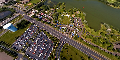 360 degree aerial panorama over the Slice of Shoreview parade in Shoreview, MN. Visible landmarks include Island Lake Park, Snail Lake, and Lake Owasso.
Equipment: NikonD70, Sigma 8mm
Helicopter: Whirlwind Helicopters
Pilot: Ray
Categories: Shoreview
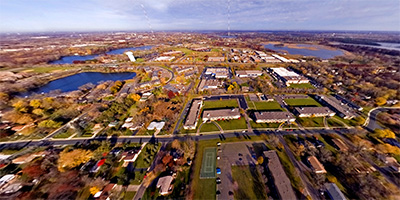 360 degree aerial panorama over the Shoreview, MN industrial corridor on Country Rd. E. Visible landmarks include Island Lake Park, Snail Lake, and Lake Owasso.
Equipment: NikonD70, Sigma 8mm
Helicopter: Davis Aviation
Pilot: Joanne Boyer
Categories: Shoreview
 360 degree aerial panorama over Shoreview’s Lake Judy, between Lexington and Victoria. Visible landmarks include Lake Owasso, Lake Johanna, and Lake Josephine.
Equipment: DJI P4P, 24 mm
Categories: Shoreview
 360 degree aerial panorama over Shoreview’s Snail Lake directly across from the community center and indoor water park.
Equipment: NikonD70, Sigma 8mm
Helicopter: Hummingbird Helicopters
Pilot: John Lindstrom
Categories: Shoreview
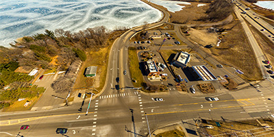
 360 degree aerial panorama over Shoreview’s Town Center, intersection of Lexington Ave. and Hwy 96
Equipment: NikonD70, Sigma 8mm
Helicopter: Hummingbird Helicopters
Pilot: John Lindstrom
Categories: Shoreview
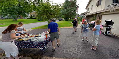 360 degree panorama at the 2011 Cobb Rd. Block Party in Shoreview, Minnesota.
Equipment: Nikon D700, Nikkor 10.5mm (shaved), Nodal Ninja Ultimate R1
Categories: Shoreview
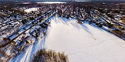
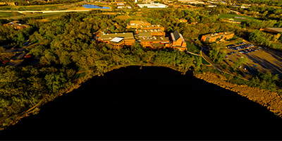
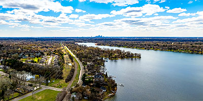 360 degree aerial panorama 400' over the east side of Lake Owasso in Shoreview, MN.
Equipment: DJI Air2s, 22 mm
Categories: Quadcopter, Shoreview
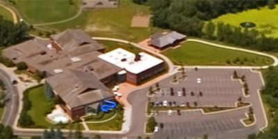
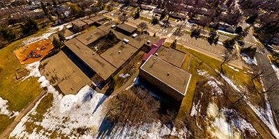 360 degree aerial panorama over Emmet D. Williams Elementary School in Shoreview, MN
Equipment: DJI P3A, 20 mm
Categories: Quadcopter, Shoreview
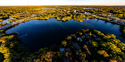 360 degree aerial panorama at sunset over Island Lake Park in Shoreview, MN.
Equipment: DJI Air2s, 22 mm
Categories: Quadcopter, Shoreview
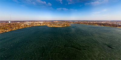 360 degree aerial panorama over Lake Owasso in Shoreview, MN.
Equipment: DJI P3A, 20 mm
Categories: Quadcopter, Shoreview
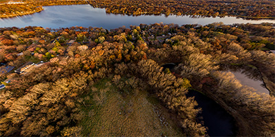
 Over Lake Valentine next to Bethel University in Arden Hills, Minnesota
Equipment: DJI P4P, 24 mm
Categories: Quadcopter, Shoreview
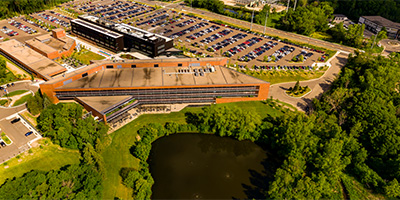 360 degree aerial panorama of the corporate headwarters of Land O' Lakes in Arden Hills, MN.
Equipment: DJI P4P, 24 mm
Categories: Quadcopter, Shoreview
 360 degree aerial panorama over Roseville Valley Park in Roseville, MN.
Equipment: DJI P4P, 24 mm
Categories: Quadcopter, Shoreview
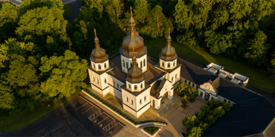 Saint Katherine Ukrainian Orthodox Church 360 degree aerial panorama.
Equipment: DJI P3A, 20 mm
Categories: Quadcopter, Shoreview
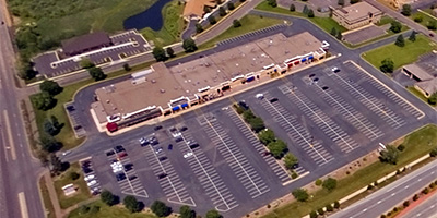
 360 degree aerial panorama over Shoreview Shopping Center.
Equipment: DJI P3A, 20 mm
Categories: Quadcopter, Shoreview
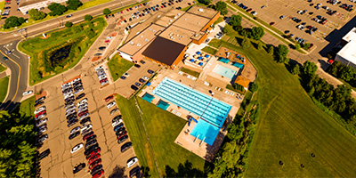 360 degree aerial panorama over the YMCA in Shoreview, MN.
Equipment: DJI P4P, 24 mm
Categories: Quadcopter, Shoreview
 360 degree panorama of Allina Health at the 2021 Slice of Shoreview parade.
Equipment: Ricoh Theta Z1, FE
Categories: Shoreview
 360 degree panorama of Edina Realty in the 2021 Slice of Shoreview parade.
Equipment: Ricoh Theta Z1, FE
Categories: Shoreview
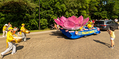 360 degree panorama of FALUN DAFA float at the 2021 Slice of Shoreview parade.
Equipment: Ricoh Theta Z1, FE
Categories: Shoreview
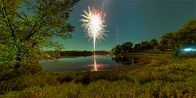 360 degree panorama of fireworks at the 2021 Slice of Shoreview.
Equipment: Ricoh Theta Z1, FE
Categories: Shoreview
 360 degree panorama of Jason Ike Isaacson supporters at the 2021 Slice of Shoreview parade.
Equipment: Ricoh Theta Z1, FE
Categories: Shoreview
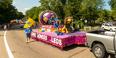 360 degree panorama of Lions Club International float at the 2021 Slice of Shoreview parade.
Equipment: Ricoh Theta Z1, FE
Categories: Shoreview
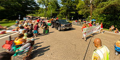
 360 degree panorama of a marching band at the 2021 Slice of Shoreview parade.
Equipment: Ricoh Theta Z1, FE
Categories: Shoreview
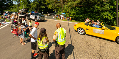 360 degree panorama of Ramsey County Sheriff's Staff at the 2021 Slice of Shoreview parade.
Equipment: Ricoh Theta Z1, FE
Categories: Shoreview
 360 degree panorama of Winter Carnival Royalty at the 2021 Slice of Shoreview parade.
Equipment: Ricoh Theta Z1, FE
Categories: Shoreview
 360 degree panorama of Zuhrah's Steel Drum Band at the 2021 Slice of Shoreview parade.
Equipment: Ricoh Theta Z1, FE
Categories: Shoreview
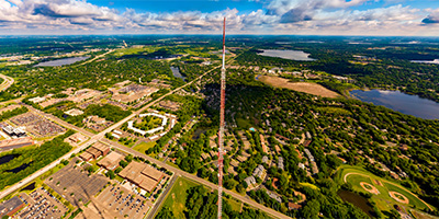 360 degree aerial panorama at the Telefarm Towers in Shoreview, MN. These are 1436' transmission towers for Twin Cities television stations WCCO, KSTP, KARE, and many radio stations. The towers were replacements for a tower that collapsed in 1971, killing six workers on the tower and one on the ground.
This is the highest altitude quadcopter aerial I've done so far. (It's also higher than all but one of my helicopter panoramas!) Normally 400' is the max alititude for a drone, but the FAA allows flights up to 400' HIGHER than nearby structures.
360 degree aerial panorama at the Telefarm Towers in Shoreview, MN. These are 1436' transmission towers for Twin Cities television stations WCCO, KSTP, KARE, and many radio stations. The towers were replacements for a tower that collapsed in 1971, killing six workers on the tower and one on the ground.
This is the highest altitude quadcopter aerial I've done so far. (It's also higher than all but one of my helicopter panoramas!) Normally 400' is the max alititude for a drone, but the FAA allows flights up to 400' HIGHER than nearby structures.
Equipment: DJI P4P, 24 mm
Categories: Industrial, Quadcopter, Shoreview
 360 degree aerial panorama over Twin Cities Army Ammunition Plant in Mounds View, MN.
Equipment: DJI P3A, 20 mm
Categories: Quadcopter, Shoreview
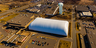 360 degree aerial panorama above Vadnais Sports Center in Vadnais Heights, MN.
Equipment: DJI P3A, 20 mm
Categories: Quadcopter, Shoreview
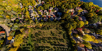 360 degree aerial panorama over Victoria Valley Orchard in Shoreview, MN.
Equipment: DJI P4P, 24 mm
Categories: Apple Orchards, Quadcopter, Shoreview
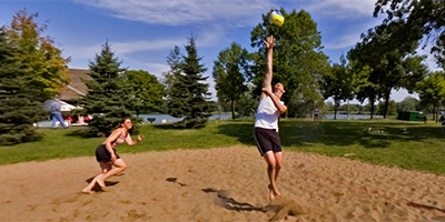 360 degree panorama of a volleyball game at Island Lake Park during the Slice of Shoreview.
Equipment: NikonD70, Sigma 8mm, Kaidan QuickPan III
Categories: Shoreview
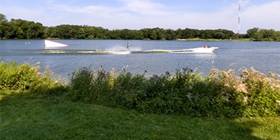 360 degree panorama of the water skiing at Island Lake Park during the Slice of Shoreview.
Equipment: NikonD70, Sigma 8mm, Kaidan QuickPan III
Categories: Shoreview
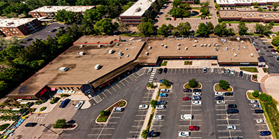 360 degree aerial panorama above Arden Plaza Shopping Center in Arden Hills, MN.
Equipment: DJI P4P, 20 mm
Categories: Quadcopter, Shoreview

Start with the "Featured" category to see an assortment of my most interesting panoramas.