Welcome to BigEyeInTheSky.com
I'm Ed Fink, these are my 360 degree panoramas. I was the first photographer in the world to shoot 360 degree panoramas from a helicopter. Today I'm a FAA licensed drone pilot and shoot most of my aerials with a quadcopter.
In addition to shooting aerial panoramas, I'm also a Google Street View Trusted Photographer in Minneapolis shooting Street View tours inside local businesses.
I publish thousands of 360 degree panoramas and virtual tours to Google Maps, where I currently have over 100 MILLION VIEWS.
Ask me for more information or an estimate for your business!
Facebook - BigEyeInTheSky360
Google Maps - Ed Fink


VISITOR COMMENTS:
"That's the coolest thing on the web."
"You brought tears to my eyes."
"Mind blowing."
"One of the neatest photo sites I've ever seen."
"I'm afraid of heights and when I looked straight down I nearly threw up!"
"I am stunned by the quality and possible applications, nice job."
"That combo of eye-in-the-sky with eyes on the ground is fantastic."
"I sent this to every pilot I know."
"HOW IS THIS EVEN POSSIBLE?!"
"The 360 shots are almost unbelieveable!!!!"
"Oh my gosh Ed - they are just beautiful."
"That aerial panorama over Lake Calhoun is totally awesome"
"FANTASTIC!!!!"
"I've instantly become a fan of your panorama photos!"
"Wow, your panoramas are like nothing I have ever seen before. Very impressive!"
"the absolute best I have seen anywhere."
"ED - I am not surprised by all the comments you have received. The VR is AWESOME!"


Select a panorama category:
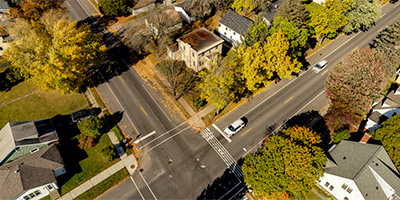 360 degree aerial panorama at Bob Dylan's childhood home in Hibbing, MN. Look for the musical staff crosswalk at the intersection below, on Bob Dylan Drive, of course. Dylan's house is at the far end of the crosswalk. It's owned by Dylan superfan, archivist, and collector Bill Pagel who occasionally gives personal tours of the house. Really nice guy, stop and visit! Bill also runs the Dylan website boblinks.com
Equipment: DJI Air2s, 22 mm
Categories: Iron Range, Music, Quadcopter
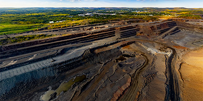
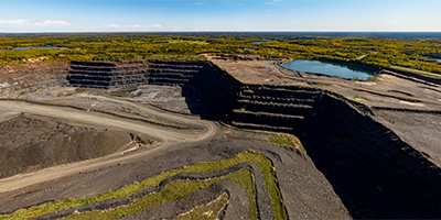 360 degree aerial panorama over an open-pit iron mine owned by Cleveland-Cliffs north of Gilbert, MN.
Equipment: DJI Air2s, 22 mm
Categories: Industrial, Iron Range, Quadcopter
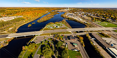 360 degree aerial panorama over Dunlap Island Park on the St. Louis River in Cloquet, MN.
Equipment: DJI Air2s, 22 mm
Categories: Duluth, Iron Range, Quadcopter
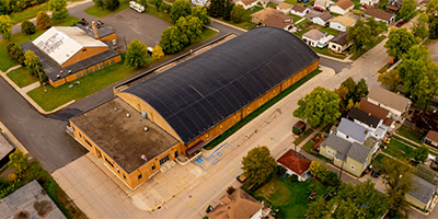 360 degree aerial panorama showing the Eveleth Hippodrome in Eveleth, MN.
Equipment: DJI Air2s, 22 mm
Categories: Iron Range, Quadcopter
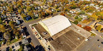 360 degree aerial panorama over the Hibbing City Memorial Building in Hibbing, MN.
Equipment: DJI Air2s, 22 mm
Categories: Iron Range, Quadcopter
 360 degree aerial panorama over the Hill of Three Waters north of Hibbing, MN. This is one of five intersections of continental divides in the U.S., where water drains to three different watersheds. This is the intersection of the Northern Divide with the St. Lawrence Seaway Divide. From this point water flows north to the Hudson Bay, south to the Gulf of Mexico, and east to the Gulf of St. Lawrence. Chippewa Indians held important council meetings here at "The Top of the World".
Now this is the HullRustMahoning Open Pit Iron Mine, which is the largest open-pit iron mine in the world, stretching over three miles long, two miles wide, and 535 feet deep.
360 degree aerial panorama over the Hill of Three Waters north of Hibbing, MN. This is one of five intersections of continental divides in the U.S., where water drains to three different watersheds. This is the intersection of the Northern Divide with the St. Lawrence Seaway Divide. From this point water flows north to the Hudson Bay, south to the Gulf of Mexico, and east to the Gulf of St. Lawrence. Chippewa Indians held important council meetings here at "The Top of the World".
Now this is the HullRustMahoning Open Pit Iron Mine, which is the largest open-pit iron mine in the world, stretching over three miles long, two miles wide, and 535 feet deep.
Equipment: DJI Air2s, 22 mm
Categories: Featured, Industrial, Iron Range, Quadcopter
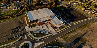 360 degree aerial panorama at the Iron Trail Motors Event Center in Virginia, MN.
Equipment: DJI Air2s, 22 mm
Categories: Iron Range, Quadcopter
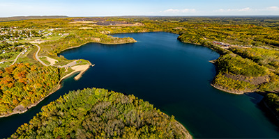 360 degree aerial panorama over Lake Ore-be-gone in Gilbert, MN. This is a 140 acre lake formed by the flooding of three open-pit iron ore mines. The name is a pun on the well-known Minnesota fictional town of Lake Wobegon, which is what made me notice it on the map and go shoot this panorama. Whoever named this should get an award for humor and creativity. Regardless of the Lake Wobegone pun, it is SO PERFECTLY DESCRIPTIVE. All the ore be gone!
Equipment: DJI Air2s, 22 mm
Categories: Iron Range, Quadcopter
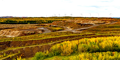 360 degree aerial panorama near the Laurentian Divide which separates the watershed of the Atlantic Ocean from the Hudson Bay watershed. I think the line of wind turbines on the ridge are the actual Laurentian Divide, but we couldnt get any closer. Mining company guards stopped us from one direction, this is the closest we could get from the other direction in our little Toyota Corrolla.
Equipment: DJI Air2s, 22 mm
Categories: Iron Range, Quadcopter
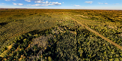
 360 degree aerial panorama over the lake that Leonidas Overlook "overlooks".
Equipment: DJI Air2s, 22 mm
Categories: Iron Range, Quadcopter
 360 degree aerial panorama above the site of the plane crash that killed Sen. Paul Wellstone, his wife, daughter, and several other people on October 25, 2002. The plane was flying slowly and too low as it approached the Eveleth airport, and according to NTSB records it crashed at the exact GPS coordinates below. I think the aviation term is CFIT - Controlled Flight Into Terrain.
Equipment: DJI Air2s, 22 mm
Categories: Iron Range, Quadcopter
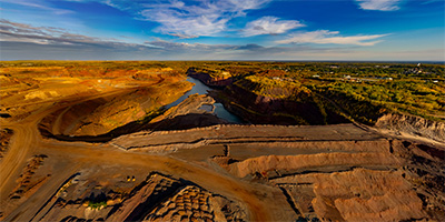
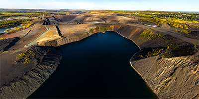
 360 degree aerial panorama over the Rouchleau Mine, east of Virginia, MN. The abandonded mine is now the source of Virginia Minnesota's drinking water.
Equipment: DJI Air2s, 22 mm
Categories: Industrial, Iron Range, Quadcopter
 360 degree aerial panorama over the United Taconite Mine in Eveleth, MN.
Equipment: DJI Air2s, 22 mm
Categories: Industrial, Iron Range, Quadcopter
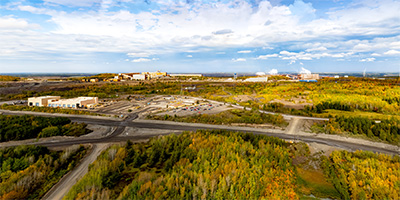 360 degree aerial panorama over US Steel Minntac in Mountain Iron, MN. Mountain Iron is the location of the first iron discovered in the area and helped make Minnesota the nations's largest iron producer and the United States the world's largest steel manufacturer.
Equipment: DJI Air2s, 22 mm
Categories: Industrial, Iron Range, Quadcopter
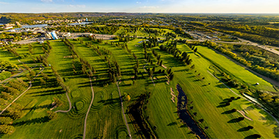 360 degree aerial panorama over the Virginia Golf Course in Virginia, MN
Equipment: DJI Air2s, 22 mm
Categories: Iron Range, Quadcopter
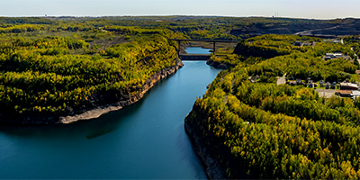
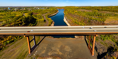 360 degree aerial panorama south of the Virginia High Bridge / Rouchleau Bridge / U.S. Hwy 53 Bridge / Rukavina Memorial Bridge / Mesabi Trail Brsidge. (I guess its's too impressive of a bridge to get by with just two or three names.) This is the tallest bridge in Minnesota.
Equipment: DJI Air2s, 22 mm
Categories: Bridges, Iron Range, Quadcopter

Start with the "Featured" category to see an assortment of my most interesting panoramas.