Welcome to BigEyeInTheSky.com
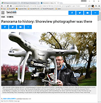
I'm Ed Fink, these are my 360 degree panoramas. I was the first photographer in the world to shoot 360 degree panoramas from a helicopter. Today I'm a FAA licensed drone pilot and shoot most of my aerials with a quadcopter.
In addition to shooting aerial panoramas, I'm also a Google Street View Trusted Photographer in Minneapolis shooting Street View tours inside local businesses.
I publish thousands of 360 degree panoramas and virtual tours to Google Maps, where I currently have over 100 MILLION VIEWS.
Ask me for more information or an estimate for your business!
Facebook - BigEyeInTheSky360
Google Maps - Ed Fink


VISITOR COMMENTS:
"That's the coolest thing on the web."
"You brought tears to my eyes."
"Mind blowing."
"One of the neatest photo sites I've ever seen."
"I'm afraid of heights and when I looked straight down I nearly threw up!"
"I am stunned by the quality and possible applications, nice job."
"That combo of eye-in-the-sky with eyes on the ground is fantastic."
"I sent this to every pilot I know."
"HOW IS THIS EVEN POSSIBLE?!"
"The 360 shots are almost unbelieveable!!!!"
"Oh my gosh Ed - they are just beautiful."
"That aerial panorama over Lake Calhoun is totally awesome"
"FANTASTIC!!!!"
"I've instantly become a fan of your panorama photos!"
"Wow, your panoramas are like nothing I have ever seen before. Very impressive!"
"the absolute best I have seen anywhere."
"ED - I am not surprised by all the comments you have received. The VR is AWESOME!"


Select a panorama category:
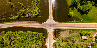 360 degree aerial panorama over a flooded intersection near the Minnesota River in Blakeley, MN.
Equipment: DJI Air2s, 22 mm
Categories: Bridges, Minnesota River, Outstate Minnesota, Quadcopter
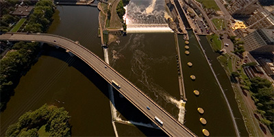
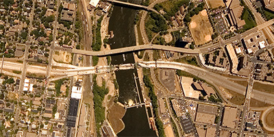
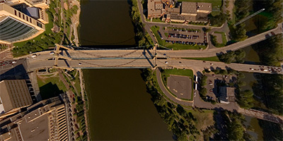
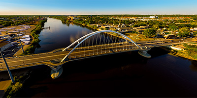
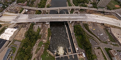
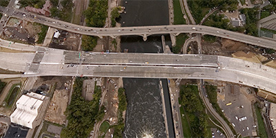
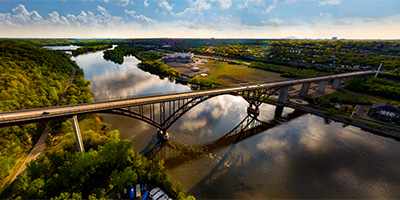
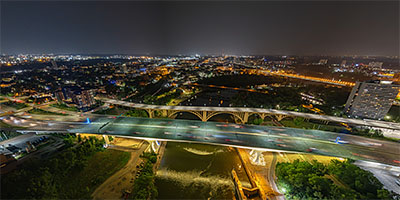 360 degree aerial panorama over Lock and Dam #1 near the I-35W Mississippi River Bridge in Minneapolis, MN, a few days after the 16th anniversary of the bridge collapse.
Equipment: DJI Air2s, 22 mm
Categories: 35W Bridge Collapse, Bridges, Featured, Minneapolis, Mississippi River, Quadcopter
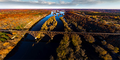 Sunrise at the Arcola High Bridge over the Saint Croix River.
Equipment: DJI P4P, 24 mm
Categories: Bridges, Featured, Quadcopter, St Croix River
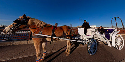 360 degree panorama of The Hitching Company’s horse and carriage on the Stone Arch Bridge. The Hitching Company offers carriage ride tours along the Mississippi River and Nicollet Mall in downtown Minneapolis.
Equipment: NikonD70, Sigma 8mm, Kaidan QuickPan III
Categories: Bridges, Minneapolis, Mississippi River
 360 degree aerial panorama over the Central/Third Ave. Bridge across the Mississippi River in downtown Minneapolis. Visible landmarks from here include Nicollet Island, St. Anthony Falls, and the Metrodome.
Equipment: Nikon D70s, Sigma 8mm, PocketWizard Plus
Helicopter: Davis Aviation
Pilot: Mark Boyer
Categories: Bridges, Minneapolis, Mississippi River
 360 degree aerial panorama on 2nd St. near the collapsed I-35W.bridge spanning the Mississippi River in Minneapolis, MN.
My 8mm fisheye lens leaves me at a real disadvantage from this far back.
Equipment: NikonD70, Sigma 8mm, Nodal Ninja 3, PocketWizard Plus
Categories: 35W Bridge Collapse, Bridges, Minneapolis, Mississippi River
 360 degree panorama showing the collapsed I-35W bridge from the University of Minnesota’s bikeway bridge over the Mississippi River.
This was shot August 15th, the morning Mayor Rybak ordered the bikeway reopened, but by the afternoon Sheriff Stanek ordered the bikeway closed again.
Equipment: NikonD70, Sigma 8mm, Nodal Ninja 3, PocketWizard Plus
Categories: 35W Bridge Collapse, Bridges, Minneapolis, Mississippi River, University of Minnesota
 360 degree panorama from the University Ave. overpass near the collapsed I-35W.bridge.
Equipment: NikonD70, Sigma 8mm, Nodal Ninja 3, PocketWizard Plus
Categories: 35W Bridge Collapse, Bridges, Minneapolis, Mississippi River
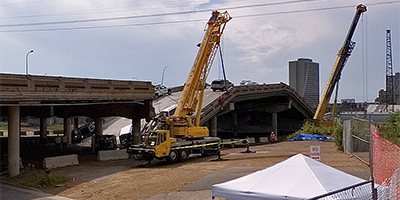
 360 degree aerial panorama over the collapsed I-35W bridge spanning the Mississippi River in Minneapolis, MN.
This was shot the morning after the collapse when there was a TFR (temporary flight restriction) over the bridge, and I had to fly significantly higher than I normally shoot, so you won’t be able to see much detail in the bridge. I may be able to do more at a decent altitude when the TFR is lifted.
Equipment: Nikon D70s, Sigma 8mm, PocketWizard Plus
Helicopter: Davis Aviation
Pilot: Joanne Boyer
Categories: 35W Bridge Collapse, Bridges, Minneapolis, Mississippi River
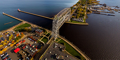 360 degree aerial panorama of Duluth Harbor and Aerial Lift Bridge.
Equipment: DJI P3A, 20 mm
Categories: Bridges, Duluth, Featured, Quadcopter
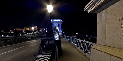
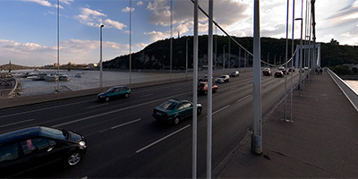 360 degree panorama on the Elizabeth Bridge over the Danube that connects the twin cities of Buda and Pest. Piarista Church at the foot of the Pest side of the bridge was moved over ten feet from it’s original location to make way for the bridge.
Equipment: NikonD70s, Sigma 8mm, Nodal Ninja 3 on 12' pole, PocketWizard Plus
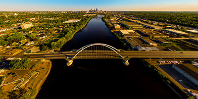
 360 degree aerial panorama over the Father Louis Hennepin Bridge, aka First Bridge, built on the site of the first bridge anywhere on the entire length of the Mississippi River. Visible landmarks from here include Nicollet Island, St. Anthony Falls, and downtown Minneapolis.
Equipment: Nikon D70s, Sigma 8mm, PocketWizard Plus
Helicopter: Davis Aviation
Pilot: Mark Boyer
Categories: Bridges, Minneapolis, Mississippi River
 Mississippi River bridge at Hastings, MN.
Equipment: DJI P4P, 24 mm
Categories: Bridges, Mississippi River, Quadcopter
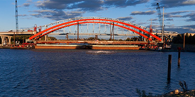 360 degree panorama on the west bank of the Mississippi River in Hastings, MN as the new bridge is floated into place.
Equipment: Nikon D700, Nikkor 10.5mm (shaved), Nodal Ninja Ultimate R1 on 12' Pole
Categories: Bridges, Mississippi River, Outstate Minnesota, World Wide Panorama
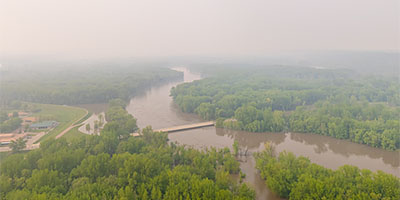
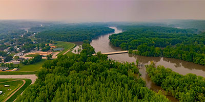 360 degree aerial panorama over flooded farmland on the Minnesota River in Henderson, MN. Haze due to wildfires in Canada.
Equipment: DJI Air2s, 22 mm
Categories: Bridges, Minnesota River, Outstate Minnesota, Quadcopter
 360 degree aerial panorama over flooded farmland on the Minnesota River in Henderson, MN. Alternate version using NO Dehaze.
Equipment: DJI Air2s, 22 mm
Categories: Bridges, Minnesota River, Outstate Minnesota, Quadcopter
 360 degree panorama at the Hennepin Ave. Bridge, which is at the site of the first permanent bridge across the Mississippi River, anywhere along it’s length. The large building at the base of the bridge on the right is the Minneapolis Post Office, and is on the site of the first permanent white dwelling on this side of the river.
Equipment: Nikon D70, Sigma 8mm
Categories: Bridges, Minneapolis, Mississippi River
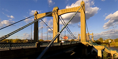
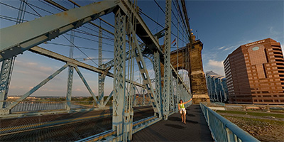 Sunset from the John Roebling Suspension Bridge connecting Cincinnati and Covington.
Equipment: ,
Categories: Bridges, Cincinnati, Ohio
 Over the Mississippi River near the Lowry Avenue Bridge in Minneapolis, Minnesota
Equipment: DJI P4P, 24 mm
Categories: Bridges, Minneapolis, Mississippi River, Quadcopter
 360 degree panorama of the Father Louis Hennepin Bridge as it disappears into the morning fog over the Mississippi River in downtown Minneapolis during the first week of spring. The bridge is in First Bridge Park, and was built at the site of the first bridge in the country to span the Mississippi River.
The only building visible in the fog is the Minneapolis Post Office, which is on the site of the first permanent white dwelling on the west bank of the river.
This was an alternate shot for the 2007 Spring Equinox World Wide Panorama "Atmosphere" event.
Equipment: Nikon D70s, Sigma 8mm, Kaidan QuickPan III
Categories: Bridges, Minneapolis, Mississippi River, World Wide Panorama
 360 degree panorama of the Father Louis Hennepin Bridge disappearing into the morning fog over the Mississippi River in downtown Minneapolis during the first week of spring. The bridge is in First Bridge Park, and was built at the site of the first bridge in the country to span the Mississippi River.
The only building visible in the fog is the Minneapolis Post Office, which is on the site of the first permanent white dwelling on the west bank of the river.
This was my submission for the 2007 Spring Equinox World Wide Panorama "Atmosphere" event.
Equipment: Nikon D70s, Sigma 8mm, Kaidan QuickPan III
Categories: Bridges, Minneapolis, Mississippi River, World Wide Panorama
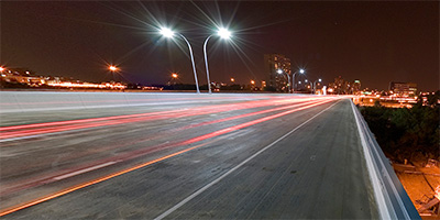 360 degree panorama at night from the I-35W Mississippi River Bridge in Minneapolis, Minnesota. This was shot the first weekend after the bridge was complete. When I started setting up, the river boat had just entered the Lower Saint Anthony Lock from downstream, and by the time I was finished shooting the lock had filled and the boat was leaving.
Don’t try shooting here yourself! A lady cop showed up just as I finished and she wrote me a ticket and gave me an angry 20 minute pedestrian safety lecture. You don’t want to run into her - she’s kind of "excitable". Any other cop would have ignored me, or calmly said "You’re not allowed to walk on the bridge, move on please." No - this cop doesn’t know the meaning of calm. She was almost hysterical, SCREAMING: "WHAT THE HELL DO YOU THINK YOU’RE DOING??!! WHO THE HELL DO YOU THINK YOU ARE???!! YOU’RE CRAZY!!!! YOU’RE OUT OF YOUR MIND!!!! WHAT AN IDIOT!!!! NOW I HAVE TO WASTE MY TIME WRITING YOU A CITATION!!"
I’ve got a bad knee, and as I was struggling to get out of her back seat with all my equipment, she started screaming again: "HURRY UP SIR! COME ON NOW!!! I DON"T HAVE ALL NIGHT!! GET!!! OUT!!!!"
I was hoping she’d just yell and not give me a ticket (no such luck!), so I was super polite to her. If that’s the way she treats a quiet, polite, professional photographer over twice her age, she must be hell on REAL criminals, like jaywalkers and litterbugs!!
Maybe she thought if she screamed enough she could "get through to me" and one day I would thank her for making me a better pedestrian? Yawn
not likely. I’ve done things FAR stupider than walking on a bridge. :)
Equipment: Nikon D70s, Sigma 8mm, Nodal Ninja 3, PocketWizard Plus
Categories: 35W Bridge Collapse, Bridges, Minneapolis, Mississippi River
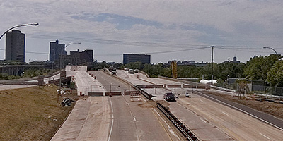
 360 degree aerial panorama west of the new I-35W bridge spanning the Mississippi River in Minneapolis, MN.
Equipment: Nikon D70s, Sigma 8mm, PocketWizard Plus
Categories: 35W Bridge Collapse, Bridges, Mississippi River, WCCO
 360 degree aerial panorama over new I-35W bridge spanning the Mississippi River in Minneapolis, MN.
Equipment: Nikon D70s, Sigma 8mm, PocketWizard Plus
Categories: 35W Bridge Collapse, Bridges, Mississippi River, WCCO
 360 degree panorama of the Central Ave. bridge and downtown Minneapolis from Nicollet Island at sunset.
Equipment: Nikon D70, Sigma 8mm
Categories: Bridges, Minneapolis, Mississippi River
 North of the Lowry Avenue Bridge over the Mississippi River in Minneapolis, Minnesota
Equipment: DJI P4P, 24 mm
Categories: Bridges, Minneapolis, Mississippi River, Quadcopter
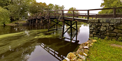 360 degree panorama next to the Old North Bridge in Concord, MA, where the Shot Heard ’Round the World was fired which began the American Revolution.
Equipment: Nikon D70, Sigma 8mm
Categories: Bridges, Veterans, World Wide Panorama
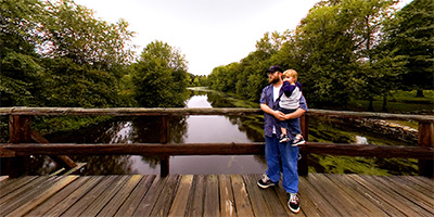 360 degree panorama on the Old North Bridge in Concord, MA, where the Shot Heard ’Round the World was fired which began the American Revolution.
Equipment: Nikon D70, Sigma 8mm
Categories: Bridges, Featured, Veterans, World Wide Panorama
 360 degree panorama of the press conference to announce the completion of the Saint Anthony Falls I-35W bridge Minneapolis, Minnesota. Speakers include U. S. Secretary of Transportation Mary Peters, Minnesota Governor Tim Pawlenty, Mayor R.T. Rybak, Senator Norm Coleman, Senator Amy Klobuchar, Congressman Tim Walz, Congressman John Kline, Congresswoman Betty McCollum, Congressman Keith Ellison, Congresswoman Michelle Bachmann, and Congressman James Oberstar.
Equipment: Nikon D70s, Sigma 8mm, Nodal Ninja 3 on 10' pole, PocketWizard Plus
Categories: 35W Bridge Collapse, Bridges, Mississippi River, WCCO
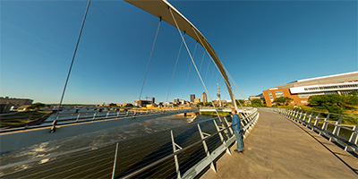
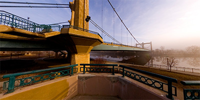
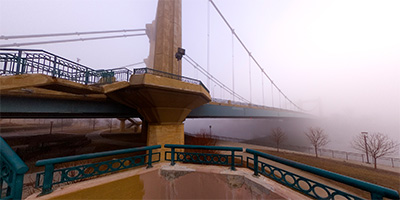
 360 degree aerial panorama at the High Bridge near downtown Saint Paul, MN.
Equipment: DJI P4P, 24 mm
Categories: Bridges, Mississippi River, Quadcopter, Saint Paul, World Wide Panorama
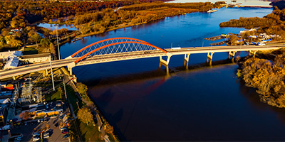
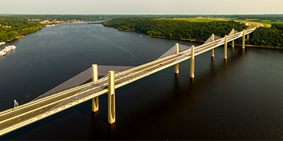 St. Croix Crossing aerial panorama from 380’.
Equipment: DJI P3A, 20 mm
Categories: Bridges, Quadcopter, St Croix River, Stillwater
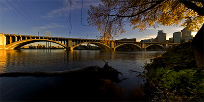
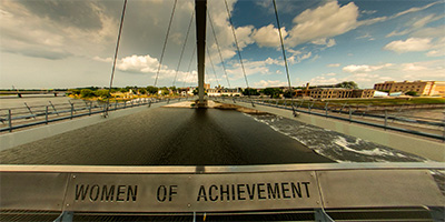
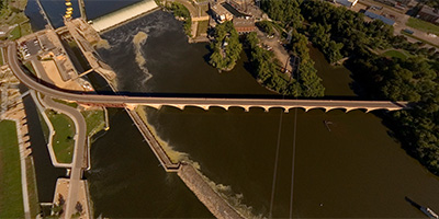 The Stone Arch Bridge near downtown Minneapolis used to be a railroad bridge. Today it a pedestrian and bicycle bridge. It is the only arched bridge made of stone on the entire length of the Mississippi River.
Equipment: Nikon D70s, Sigma 8mm, PocketWizard Plus
Helicopter: Davis Aviation
Pilot: Mark Boyer
Categories: Bridges, Minneapolis, Mississippi River
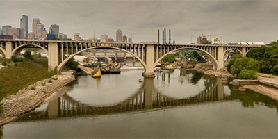
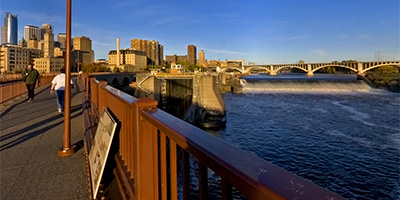 360 degree panorama of the St. Anthony Falls, Mississippi River lock and dam, and downtown Minneapolis from the Stone Arch Bridge at sunrise.
Equipment: Nikon D70, Sigma 8mm
Categories: Bridges, Minneapolis, Mississippi River
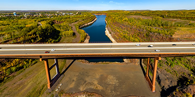 360 degree aerial panorama south of the Virginia High Bridge / Rouchleau Bridge / U.S. Hwy 53 Bridge / Rukavina Memorial Bridge / Mesabi Trail Brsidge. (I guess its's too impressive of a bridge to get by with just two or three names.) This is the tallest bridge in Minnesota.
Equipment: DJI Air2s, 22 mm
Categories: Bridges, Iron Range, Quadcopter

Start with the "Featured" category to see an assortment of my most interesting panoramas.