Welcome to BigEyeInTheSky.com
I'm Ed Fink, these are my 360 degree panoramas. I was the first photographer in the world to shoot 360 degree panoramas from a helicopter. Today I'm a FAA licensed drone pilot and shoot most of my aerials with a quadcopter.
In addition to shooting aerial panoramas, I'm also a Google Street View Trusted Photographer in Minneapolis shooting Street View tours inside local businesses.
I publish thousands of 360 degree panoramas and virtual tours to Google Maps, where I currently have over 100 MILLION VIEWS.
Ask me for more information or an estimate for your business!
Facebook - BigEyeInTheSky360
Google Maps - Ed Fink

VISITOR COMMENTS:
"That's the coolest thing on the web."
"You brought tears to my eyes."
"Mind blowing."
"One of the neatest photo sites I've ever seen."
"I'm afraid of heights and when I looked straight down I nearly threw up!"
"I am stunned by the quality and possible applications, nice job."
"That combo of eye-in-the-sky with eyes on the ground is fantastic."
"I sent this to every pilot I know."
"HOW IS THIS EVEN POSSIBLE?!"
"The 360 shots are almost unbelieveable!!!!"
"Oh my gosh Ed - they are just beautiful."
"That aerial panorama over Lake Calhoun is totally awesome"
"FANTASTIC!!!!"
"I've instantly become a fan of your panorama photos!"
"Wow, your panoramas are like nothing I have ever seen before. Very impressive!"
"the absolute best I have seen anywhere."
"ED - I am not surprised by all the comments you have received. The VR is AWESOME!"


Select a panorama category:
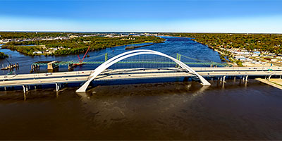
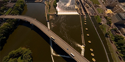
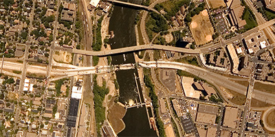
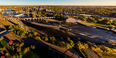
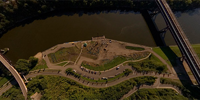
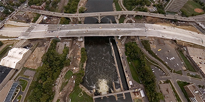
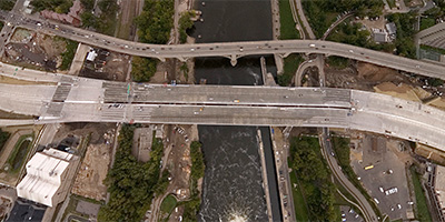
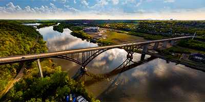
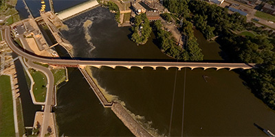
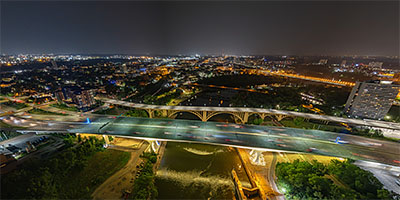 360 degree aerial panorama over Lock and Dam #1 near the I-35W Mississippi River Bridge in Minneapolis, MN, a few days after the 16th anniversary of the bridge collapse.
Equipment: DJI Air2s, 22 mm
Categories: 35W Bridge Collapse, Bridges, Featured, Minneapolis, Mississippi River, Quadcopter
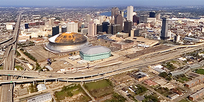 Aerial panorama near the New Orleans Superdome from a helicopter 1,000 ft. above Hwy. 90/S. Claiborne Ave. at Martin Luther King Jr. Blvd. This is almost a month after Hurricane Katrina and three days after Hurricane Rita, which accounts for the almost deserted streets and highways and the eerie ghost-town look. The Greater New Orleans Mississippi River Bridge is normally the fifth busiest toll bridge in the country.
Equipment: NikonD70, Sigma 8mm
Helicopter: Panther Helicopters
Pilot: Lance Panepinto
Categories: Hurricane Katrina, Mississippi River
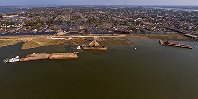 360 degree aerial photograph of the Inner Harbor Navigation Canal (aka Industrial Canal) from a helicopter 400 feet over the Galvez St. Wharf. This is between the Florida Ave. bridge and the N. Claiborne bridge where the levee to the east was breeched during Hurricane Katrina, flooding the Ninth Ward in Arabi and eastward on to Chalmette in St. Bernard Parish. The flooding shown here is from Hurricane Rita, which hit three days before this photo was taken. To the south is the Mississippi River, and upriver you can see the New Orleans skyline and the Greater New Orleans Bridge. Note Barge ING 4727, which, depending on which theory you subscribe to, was either washed over the levee, or struck the levee and actually caused the breach.
Equipment: NikonD70, Sigma 8mm
Helicopter: Panther Helicopters
Pilot: Lance Panepinto
Categories: Hurricane Katrina, Mississippi River
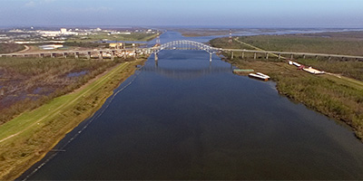 360 degree aerial panorama 400 feet above the Gulf Intracoastal Waterway in Orleans Parish, Louisiana after Hurricane Katrina. The Paris Rd. bridge is to the west. Beyond the bridge on the left is the NASA Michoud Facility, which manufactures the external fuel tanks for the Space Shuttle. Across the canal to the right you can see where the Mississippi River Gulf Outlet (the MRGO - aka Mister Go) connects to the Gulf Intracoastal Waterway. The storm surge from Hurricane Katrina flowed down this canal to the Industrial Canal, where it met water flowing south from Lake Pontchartrain, and overtopped the east levee, flooding the Ninth Ward and westward to St. Bernard Parish. Note the barges washed up on top of the levee near the base of the bridge.
Equipment: NikonD70, Sigma 8mm
Helicopter: Panther Helicopters
Pilot: Lance Panepinto
Categories: Hurricane Katrina, Mississippi River
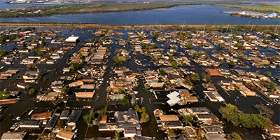 360 degree aerial panorama from a helicopter 400 feet above New Orleans’ flooded Ninth Ward. This is over Charbonnet St. at Miro St., east of the Inner Harbor Navigational Canal (aka Industrial Canal) between the Florida Ave. bridge and the N. Claiborne bridge where the levee was breeched during Hurricane Katrina - and again during Hurricane Rita. To the south is the Mississippi River, and upriver you can see the New Orleans skyline.
Equipment: NikonD70, Sigma 8mm
Helicopter: Panther Helicopters
Pilot: Lance Panepinto
Categories: Hurricane Katrina, Mississippi River
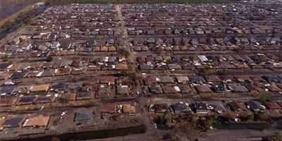 360 degree aerial photograph shoot from a helicopter 400 ft. above a muddy neighborhood in St. Bernard Parish, Louisiana after Hurricane Katrina and three days after Hurricane Rita. This is east of Paris Rd. in Chalmette. To the south is the Mississippi River, and up river to the west you can the New Orleans skyline.
Equipment: NikonD70, Sigma 8mm
Helicopter: Panther Helicopters
Pilot: Lance Panepinto
Categories: Hurricane Katrina, Mississippi River
 360 degree aerial panorama over the Mississippi River near Anoka-Ramsey Community College Coon Rapids Campus.
Equipment: DJI P4P, 24 mm
Categories: Mississippi River, Quadcopter
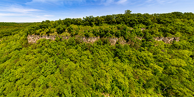
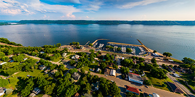
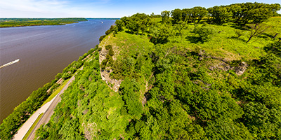
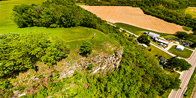
 360 degree aerial panorama at the Balltown Iowa Scenic Overlook, with Mississippi River in the distance to the north.
Equipment: DJI Air2s, 22 mm
Categories: Iowa, Mississippi River, Quadcopter
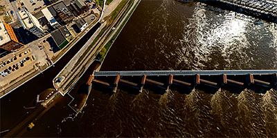
 360 degree aerial panorama at Mississippi River Lock and Dam #12 in Bellevue, IA.
Equipment: DJI Air2s, 22 mm
Categories: Iowa, Mississippi River, Quadcopter
 360 degree aerial panorama over the Mississippi River at Bettendorf, IA.
Equipment: DJI Air2s, 22 mm
Categories: Iowa, Mississippi River, Quadcopter
 360 degree aerial panorama over the Mississippi River near Boom Island and Nicollet Island . Visible landmarks from here include Nicollet Island, St. Anthony Falls, and downtown Minneapolis.
Equipment: Nikon D70s, Sigma 8mm, PocketWizard Plus
Helicopter: Davis Aviation
Pilot: Mark Boyer
Categories: Minneapolis, Mississippi River
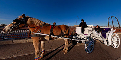 360 degree panorama of The Hitching Company’s horse and carriage on the Stone Arch Bridge. The Hitching Company offers carriage ride tours along the Mississippi River and Nicollet Mall in downtown Minneapolis.
Equipment: NikonD70, Sigma 8mm, Kaidan QuickPan III
Categories: Bridges, Minneapolis, Mississippi River
 360 degree aerial panorama over the Central/Third Ave. Bridge across the Mississippi River in downtown Minneapolis. Visible landmarks from here include Nicollet Island, St. Anthony Falls, and the Metrodome.
Equipment: Nikon D70s, Sigma 8mm, PocketWizard Plus
Helicopter: Davis Aviation
Pilot: Mark Boyer
Categories: Bridges, Minneapolis, Mississippi River
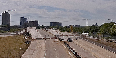
 360 degree aerial panorama on 2nd St. near the collapsed I-35W.bridge spanning the Mississippi River in Minneapolis, MN.
My 8mm fisheye lens leaves me at a real disadvantage from this far back.
Equipment: NikonD70, Sigma 8mm, Nodal Ninja 3, PocketWizard Plus
Categories: 35W Bridge Collapse, Bridges, Minneapolis, Mississippi River
 360 degree panorama showing the collapsed I-35W bridge from the University of Minnesota’s bikeway bridge over the Mississippi River.
This was shot August 15th, the morning Mayor Rybak ordered the bikeway reopened, but by the afternoon Sheriff Stanek ordered the bikeway closed again.
Equipment: NikonD70, Sigma 8mm, Nodal Ninja 3, PocketWizard Plus
Categories: 35W Bridge Collapse, Bridges, Minneapolis, Mississippi River, University of Minnesota
 360 degree panorama from the University Ave. overpass near the collapsed I-35W.bridge.
Equipment: NikonD70, Sigma 8mm, Nodal Ninja 3, PocketWizard Plus
Categories: 35W Bridge Collapse, Bridges, Minneapolis, Mississippi River
 360 degree aerial panorama over the collapsed I-35W bridge spanning the Mississippi River in Minneapolis, MN.
This was shot the morning after the collapse when there was a TFR (temporary flight restriction) over the bridge, and I had to fly significantly higher than I normally shoot, so you won’t be able to see much detail in the bridge. I may be able to do more at a decent altitude when the TFR is lifted.
Equipment: Nikon D70s, Sigma 8mm, PocketWizard Plus
Helicopter: Davis Aviation
Pilot: Joanne Boyer
Categories: 35W Bridge Collapse, Bridges, Minneapolis, Mississippi River
 Over the Mississippi River at Coon_Rapids_Dam.
Equipment: DJI P4P, 24 mm
Categories: Industrial, Mississippi River, Quadcopter
 360 degree aerial panorama over the Davenport, IA Mississippi River floodgates.
Equipment: DJI Air2s, 22 mm
Categories: Iowa, Mississippi River, Quadcopter
 360 degree aerial panorama at Diamond Bluff overlooking the Mississippi River in Diamond Bluff, WI. This was the site of one of the largest inland water catastrophes in the U.S. in 1890 when the Sea Wing, a steamboat built at the village of Diamond Bluff sank in a storm and killed 98 people.
Equipment: DJI P4P, 24 mm
Categories: Mississippi River, Quadcopter, Wisconsin
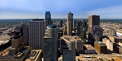 This is a 360 degree aerial panorama shot from a helicopter over downtown Minneapolis. Landmarks include Target Center and the Metrodome, and the Mississippi River, including the site of the first bridge over the river, St. Anthony Falls, and the Stone Arch Bridge.
Equipment: NikonD70, Sigma 8mm
Helicopter: Hummingbird Helicopters
Pilot: John Lindstrom
Categories: Minneapolis, Mississippi River
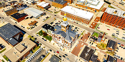 360 degree aerial panorama at the Dubuque County Courthouse in Dubuque, IA.
Equipment: DJI Air2s, 22 mm
Categories: Iowa, Mississippi River, Quadcopter
 360 degree aerial panorama over the Father Louis Hennepin Bridge, aka First Bridge, built on the site of the first bridge anywhere on the entire length of the Mississippi River. Visible landmarks from here include Nicollet Island, St. Anthony Falls, and downtown Minneapolis.
Equipment: Nikon D70s, Sigma 8mm, PocketWizard Plus
Helicopter: Davis Aviation
Pilot: Mark Boyer
Categories: Bridges, Minneapolis, Mississippi River
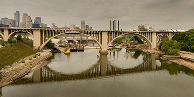
 360 degree aerial panorama directly over Gold Medal Park overlooking the Mississippi River in downtown Minnespolis, MN. The river has been drawn down to record levels to inspect the locks, exposing the river bottom in places, the exposed foot of St. Anthony Falls, and remains of older river structures.
Equipment: DJI P4P, 24 mm
Categories: 35W Bridge Collapse, Minneapolis, Mississippi River, Quadcopter, World Wide Panorama
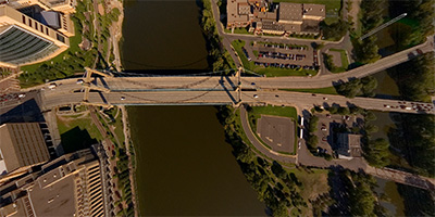
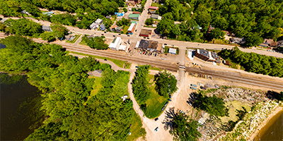
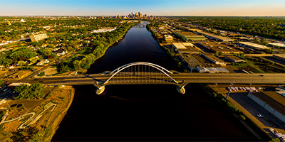
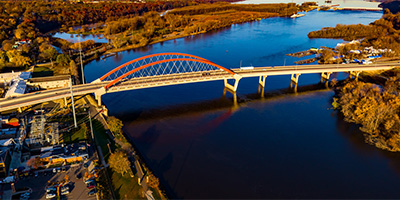 Mississippi River bridge at Hastings, MN.
Equipment: DJI P4P, 24 mm
Categories: Bridges, Mississippi River, Quadcopter
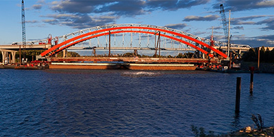 360 degree panorama on the west bank of the Mississippi River in Hastings, MN as the new bridge is floated into place.
Equipment: Nikon D700, Nikkor 10.5mm (shaved), Nodal Ninja Ultimate R1 on 12' Pole
Categories: Bridges, Mississippi River, Outstate Minnesota, World Wide Panorama
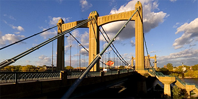 360 degree panorama at the Hennepin Ave. Bridge, which is at the site of the first permanent bridge across the Mississippi River, anywhere along it’s length. The large building at the base of the bridge on the right is the Minneapolis Post Office, and is on the site of the first permanent white dwelling on this side of the river.
Equipment: Nikon D70, Sigma 8mm
Categories: Bridges, Minneapolis, Mississippi River
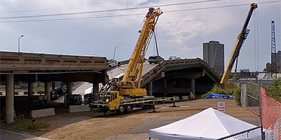
 360 degree aerial panorama over the I-35W Bridge Collapse Investigation Site across from the University of Minnesota.
Girders from the collapsed bridge are moved by barge to here and laid out for the engineers and inspectors to study.
Equipment: Nikon D70s, Sigma 8mm, PocketWizard Plus
Helicopter: Davis Aviation
Pilot: Mark Boyer
Categories: 35W Bridge Collapse, Mississippi River
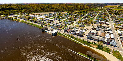
 360 degree panorama overlooking the Mississippi River from Saint Paul’s Indian Mounds Park, near the Airway Beacon.
Equipment: Nikon D700, Nikkor 10.5mm (shaved), Nodal Ninja Ultimate R1
Categories: Mississippi River, Saint Paul
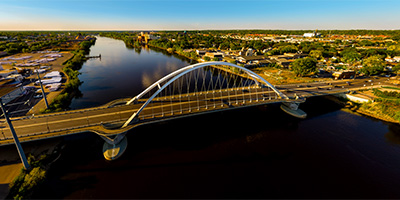
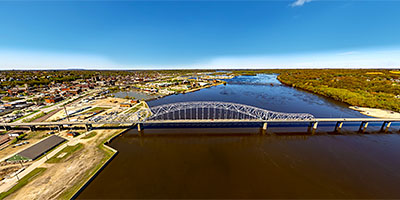 360 degree aerial panorama at the Julien Dubuque Bridge over the Mississippi River in Dubuque, IA.
Equipment: DJI Air2s, 22 mm
Categories: Iowa, Mississippi River, Quadcopter
 Keg and Case Market/Schmidt Brewery Building in Saint Paul, MN.
Equipment: DJI P4P, 24 mm
Categories: Mississippi River, Quadcopter, Saint Paul
 360 degree aerial panorama above the Laura Ingalls Wilder Museum in Pepin, WI, along the Mississippi River and Lake Pepin, WI.
Equipment: DJI P4P, 24 mm
Categories: La Crosse, Mississippi River, Quadcopter, Wisconsin
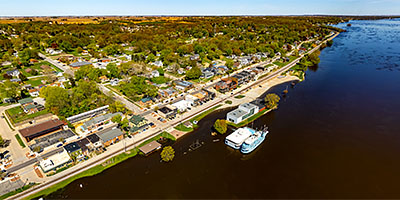 360 degree aerial panorama upriver from the Quad Cities at Le Claire, IA, over a flooded Mississippi River.
Equipment: DJI Air2s, 22 mm
Categories: Iowa, Mississippi River, Quadcopter
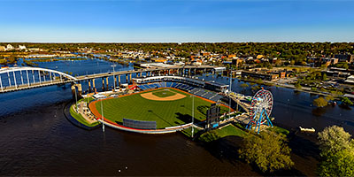
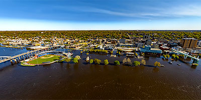 360 degree aerial panorama over flooded Mississippi River near LeClaire Park and Bandshell in downtown Davenport, IA.
Equipment: DJI Air2s, 22 mm
Categories: Iowa, Mississippi River, Quadcopter
 Over the Mississippi River near the Lowry Avenue Bridge in Minneapolis, Minnesota
Equipment: DJI P4P, 24 mm
Categories: Bridges, Minneapolis, Mississippi River, Quadcopter
 360 degree aerial panorama at Maiden Rock Bluff in Wisconsin along the Mississippi River.
Equipment: DJI P4P, 24 mm
Categories: Mississippi River, Quadcopter, Wisconsin
 360 degree aerial panorama over Maiden Rock Village Park along the Mississippi River in Maiden Rock, WI.
Equipment: DJI P4P, 24 mm
Categories: Mississippi River, Quadcopter, Wisconsin
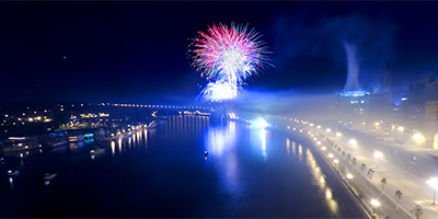 360 degree panorama from the Wabasha Bridge over the Mississippi River during the 2005 Melaleuca Freedom Celebration fireworks. Visible landmarks include downtown St. Paul and Harriet Island.
Equipment: NikonD70, Sigma 8mm, Kaidan QuickPan III
Categories: Mississippi River, Saint Paul
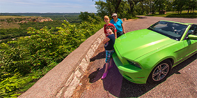 This 360 degree panorama was shot at Memorial Park on Sorkins Bluff overlooking Red Wing, Minnesota, the Mississippi River, and across to Wisconsin.
On Father’s Day weekend 2012 I went back to my panorama roots with my wife and grandkids, and rented a convertible to cruise the bluff country along the Mississippi River in southern Minnesota and Wisconsin, shooting panoramas at some of the same locations I shot 13 years ago when I first started doing interactive panoramas.
In 1999 my $1,000 digital camera took 18 shots to make a 360 degree panorama. I could fit exactly 36 shots in the camera, so if I didn’t make any mistakes I could shoot 2 panoramas before I had to do a 30 minute camera download! Because it took such an investment in time I learned to be very picky with my shots, and wanted only the most scenic locations. So I used to do "panorama weekends" where I’d rent a convertible and cruise around looking for special panoramas - like this one.
This was my submission for the "Heritage" World Wide Panorama event for Summer Solstice 2012.
Equipment: Nikon D700, Nikkor 10.5mm (shaved), Nodal Ninja Ultimate R1
Categories: Mississippi River, Outstate Minnesota, World Wide Panorama
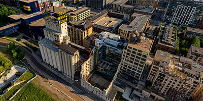
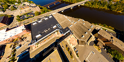
 360 degree aerial panorama at the Mill City Museum. My submission to World Wide Panorama: Museums.
The Mill City Museum is built in the ruins of what was once the worlds largest flour mill. The museum focuses on the founding and growth of Minneapolis, especially flour milling and the other industries that used hydropower from the nearby Saint Anthony Falls on the Mississippi River.
The first Washburn A Mill was the largest flour mill in the world and contributed to the development of Minneapolis. On May 2, 1878, a spark ignited airborne flour dust creating an explosion that demolished the Washburn A and killed 18 workers instantly. The ensuing fire resulted in the deaths of four more people and destroyed five other mills.
Known as the Great Mill Disaster, the explosion served as a focal point for reforms in the milling industry to prevent the buildup of combustible flour dust.
360 degree aerial panorama at the Mill City Museum. My submission to World Wide Panorama: Museums.
The Mill City Museum is built in the ruins of what was once the worlds largest flour mill. The museum focuses on the founding and growth of Minneapolis, especially flour milling and the other industries that used hydropower from the nearby Saint Anthony Falls on the Mississippi River.
The first Washburn A Mill was the largest flour mill in the world and contributed to the development of Minneapolis. On May 2, 1878, a spark ignited airborne flour dust creating an explosion that demolished the Washburn A and killed 18 workers instantly. The ensuing fire resulted in the deaths of four more people and destroyed five other mills.
Known as the Great Mill Disaster, the explosion served as a focal point for reforms in the milling industry to prevent the buildup of combustible flour dust.
Equipment: DJI Air2s, 22 mm
Categories: Minneapolis, Mississippi River, World Wide Panorama
 360 degree aerial panorama at the Mill City Museum. An alternate shot for my submission to World Wide Panorama: Museums, about 100' higher than the shot I used.
The Mill City Museum is built in the ruins of what was once the worlds largest flour mill. The museum focuses on the founding and growth of Minneapolis, especially flour milling and the other industries that used hydropower from the nearby Saint Anthony Falls on the Mississippi River.
The first Washburn A Mill was the largest flour mill in the world and contributed to the development of Minneapolis. On May 2, 1878, a spark ignited airborne flour dust creating an explosion that demolished the Washburn A and killed 18 workers instantly. The ensuing fire resulted in the deaths of four more people and destroyed five other mills.
Known as the Great Mill Disaster, the explosion served as a focal point for reforms in the milling industry to prevent the buildup of combustible flour dust.
360 degree aerial panorama at the Mill City Museum. An alternate shot for my submission to World Wide Panorama: Museums, about 100' higher than the shot I used.
The Mill City Museum is built in the ruins of what was once the worlds largest flour mill. The museum focuses on the founding and growth of Minneapolis, especially flour milling and the other industries that used hydropower from the nearby Saint Anthony Falls on the Mississippi River.
The first Washburn A Mill was the largest flour mill in the world and contributed to the development of Minneapolis. On May 2, 1878, a spark ignited airborne flour dust creating an explosion that demolished the Washburn A and killed 18 workers instantly. The ensuing fire resulted in the deaths of four more people and destroyed five other mills.
Known as the Great Mill Disaster, the explosion served as a focal point for reforms in the milling industry to prevent the buildup of combustible flour dust.
Equipment: DJI Air2s, 22 mm
Categories: Minneapolis, Mississippi River, World Wide Panorama
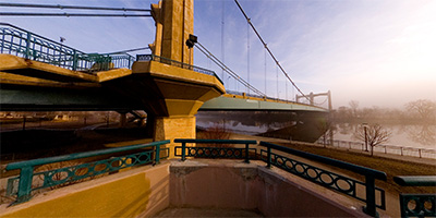 360 degree panorama of the Father Louis Hennepin Bridge as it disappears into the morning fog over the Mississippi River in downtown Minneapolis during the first week of spring. The bridge is in First Bridge Park, and was built at the site of the first bridge in the country to span the Mississippi River.
The only building visible in the fog is the Minneapolis Post Office, which is on the site of the first permanent white dwelling on the west bank of the river.
This was an alternate shot for the 2007 Spring Equinox World Wide Panorama "Atmosphere" event.
Equipment: Nikon D70s, Sigma 8mm, Kaidan QuickPan III
Categories: Bridges, Minneapolis, Mississippi River, World Wide Panorama
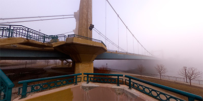 360 degree panorama of the Father Louis Hennepin Bridge disappearing into the morning fog over the Mississippi River in downtown Minneapolis during the first week of spring. The bridge is in First Bridge Park, and was built at the site of the first bridge in the country to span the Mississippi River.
The only building visible in the fog is the Minneapolis Post Office, which is on the site of the first permanent white dwelling on the west bank of the river.
This was my submission for the 2007 Spring Equinox World Wide Panorama "Atmosphere" event.
Equipment: Nikon D70s, Sigma 8mm, Kaidan QuickPan III
Categories: Bridges, Minneapolis, Mississippi River, World Wide Panorama
 360 degree aerial panorama over flooded Mississippi River near Modern Woodmen Park in Davenport, IA.
Equipment: DJI Air2s, 22 mm
Categories: Featured, Iowa, Mississippi River, Quadcopter
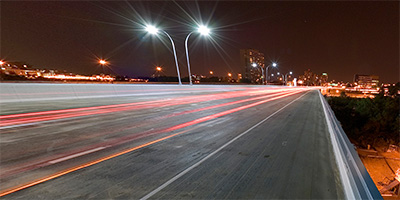 360 degree panorama at night from the I-35W Mississippi River Bridge in Minneapolis, Minnesota. This was shot the first weekend after the bridge was complete. When I started setting up, the river boat had just entered the Lower Saint Anthony Lock from downstream, and by the time I was finished shooting the lock had filled and the boat was leaving.
Don’t try shooting here yourself! A lady cop showed up just as I finished and she wrote me a ticket and gave me an angry 20 minute pedestrian safety lecture. You don’t want to run into her - she’s kind of "excitable". Any other cop would have ignored me, or calmly said "You’re not allowed to walk on the bridge, move on please." No - this cop doesn’t know the meaning of calm. She was almost hysterical, SCREAMING: "WHAT THE HELL DO YOU THINK YOU’RE DOING??!! WHO THE HELL DO YOU THINK YOU ARE???!! YOU’RE CRAZY!!!! YOU’RE OUT OF YOUR MIND!!!! WHAT AN IDIOT!!!! NOW I HAVE TO WASTE MY TIME WRITING YOU A CITATION!!"
I’ve got a bad knee, and as I was struggling to get out of her back seat with all my equipment, she started screaming again: "HURRY UP SIR! COME ON NOW!!! I DON"T HAVE ALL NIGHT!! GET!!! OUT!!!!"
I was hoping she’d just yell and not give me a ticket (no such luck!), so I was super polite to her. If that’s the way she treats a quiet, polite, professional photographer over twice her age, she must be hell on REAL criminals, like jaywalkers and litterbugs!!
Maybe she thought if she screamed enough she could "get through to me" and one day I would thank her for making me a better pedestrian? Yawn
not likely. I’ve done things FAR stupider than walking on a bridge. :)
Equipment: Nikon D70s, Sigma 8mm, Nodal Ninja 3, PocketWizard Plus
Categories: 35W Bridge Collapse, Bridges, Minneapolis, Mississippi River
 360 degree aerial panorama west of the new I-35W bridge spanning the Mississippi River in Minneapolis, MN.
Equipment: Nikon D70s, Sigma 8mm, PocketWizard Plus
Categories: 35W Bridge Collapse, Bridges, Mississippi River, WCCO
 360 degree aerial panorama over new I-35W bridge spanning the Mississippi River in Minneapolis, MN.
Equipment: Nikon D70s, Sigma 8mm, PocketWizard Plus
Categories: 35W Bridge Collapse, Bridges, Mississippi River, WCCO
 360 degree panorama of the Central Ave. bridge and downtown Minneapolis from Nicollet Island at sunset.
Equipment: Nikon D70, Sigma 8mm
Categories: Bridges, Minneapolis, Mississippi River
 North of the Lowry Avenue Bridge over the Mississippi River in Minneapolis, Minnesota
Equipment: DJI P4P, 24 mm
Categories: Bridges, Minneapolis, Mississippi River, Quadcopter
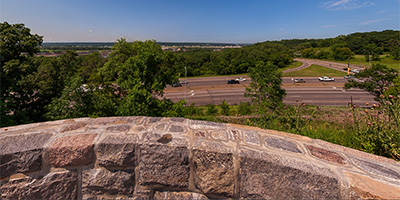 360 degree panorama from Pig’s Eye Overlook along Hwy. 61 in Saint Paul.
Equipment: Nikon D700, Nikkor 10.5mm (shaved), Nodal Ninja Ultimate R1
Categories: Mississippi River, Saint Paul
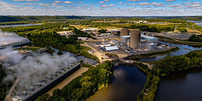 360 degree aerial panorama of the Prairie Island Nuclear Generating Plant near Red Wing, MN. This was my submission for the World Wide Panorama Equinox 2022 Climate Change theme. My first choice was to shoot a 360 of the control room interior, but after a month of trying unsuccessfully to get permission from Xcel I finally gave up. Surprisingly, I didn't need ANY permission to shoot from here.
Equipment: DJI Air2s, 22 mm
Categories: Industrial, Mississippi River, Quadcopter, World Wide Panorama
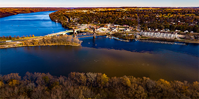 Prescott, Wisconsin, east of Hastings at the confluence of the Saint Croix River and the Mississippi River.
Equipment: DJI P4P, 24 mm
Categories: Mississippi River, Quadcopter, St Croix River
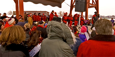
 360 degree panorama of the press conference to announce the completion of the Saint Anthony Falls I-35W bridge Minneapolis, Minnesota. Speakers include U. S. Secretary of Transportation Mary Peters, Minnesota Governor Tim Pawlenty, Mayor R.T. Rybak, Senator Norm Coleman, Senator Amy Klobuchar, Congressman Tim Walz, Congressman John Kline, Congresswoman Betty McCollum, Congressman Keith Ellison, Congresswoman Michelle Bachmann, and Congressman James Oberstar.
Equipment: Nikon D70s, Sigma 8mm, Nodal Ninja 3 on 10' pole, PocketWizard Plus
Categories: 35W Bridge Collapse, Bridges, Mississippi River, WCCO
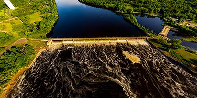
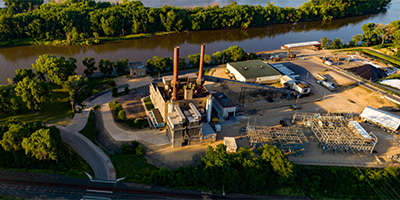 360 degree aerial panorama near Barn Bluff above the Xcel Generating Plant, which powers 50% of the homes in Red Wing, MN.
Equipment: DJI P4P, 24 mm
Categories: Industrial, Mississippi River, Quadcopter
 Memorial Park on Sorins Bluff, Red Wing, MN. 360 degree aerial panorama #2.
Equipment: DJI P3A, 20 mm
Categories: Mississippi River, Outstate Minnesota, Quadcopter
 Memorial Park on Sorins Bluff, Red Wing, MN. 360 degree aerial panorama #1.
Equipment: DJI P3A, 20 mm
Categories: Mississippi River, Outstate Minnesota, Quadcopter
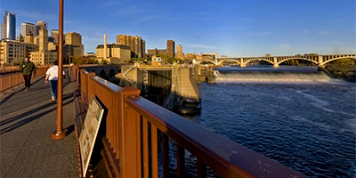
 360 degree aerial panorama in Minneapolis directly over Saint Anthony Falls, the only falls on the entire length of the Mississippi River. Visible landmarks include the Stone Arch Bridge, the Guthrie Theatre, the Metrodome, Nicollet Island, and the northernmost lock and dam on the Mississippi River.
Equipment: Nikon D70s, Sigma 8mm, PocketWizard Plus
Helicopter: Davis Aviation
Pilot: Mark Boyer
Categories: Featured, Minneapolis, Mississippi River
 360 degree aerial panorama at the High Bridge near downtown Saint Paul, MN.
Equipment: DJI P4P, 24 mm
Categories: Bridges, Mississippi River, Quadcopter, Saint Paul, World Wide Panorama
 360 degree aerial panorama above the Shrine of Our Lady of Guadalupe in La Crosse, WI.
Equipment: DJI P4P, 24 mm
Categories: La Crosse, Mississippi River, Quadcopter, Wisconsin
 360 degree aerial panorama at Skidmore Bluff, WI, 800 feet above the Mississippi River near Hager City, WI. The bluff appeared in the 1922 movie Free Air in which a villain named Pinky driving a Model T roadster plunged off the bluff to his death.
Equipment: DJI P4P, 24 mm
Categories: Mississippi River, Quadcopter, Wisconsin
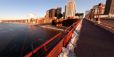 360 degree panorama from the Wabasha Bridge above the Mississippi River in downtown St. Paul during the 2011 spring floods. With the river at 17’ here, several roads have been closed, and in anticipation of the 19’ crest due in the next day or two, flood walls have been erected to limit the flooding in low lying neighborhoods and the downtown airport.
This was my submission for theWorld Wide Panorama Spring Equinox 2011 event Limits.
Equipment: Nikon D700, Nikkor 10.5mm (shaved), Nodal Ninja Ultimate R1
Categories: Mississippi River, Saint Paul, World Wide Panorama
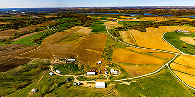
 Aerial panorama over the St Cloud Rivers Edge Convention Center.
Equipment: DJI P3A, 20 mm
Categories: Mississippi River, Quadcopter, Saint Cloud
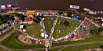 360 degree aerial panorama shot from a helicopter over Harriet Island during the Taste of Minnesota 2005. Visible landmarks include Mississippi River, Wabasha bridge, downtown St. Paul, Minnesota State Capitol.
Equipment: NikonD70, Sigma 8mm
Helicopter: Hummingbird Helicopters
Pilot: John Lindstrom
Categories: Mississippi River, Saint Paul
 The Stone Arch Bridge near downtown Minneapolis used to be a railroad bridge. Today it a pedestrian and bicycle bridge. It is the only arched bridge made of stone on the entire length of the Mississippi River.
Equipment: Nikon D70s, Sigma 8mm, PocketWizard Plus
Helicopter: Davis Aviation
Pilot: Mark Boyer
Categories: Bridges, Minneapolis, Mississippi River
 360 degree aerial panorama at Stoney Point in La Crescent, MN overlooking the Mississippi River.
Equipment: DJI P4P, 24 mm
Categories: La Crosse, Mississippi River, Quadcopter, Wisconsin
 360 degree panorama of the St. Anthony Falls, Mississippi River lock and dam, and downtown Minneapolis from the Stone Arch Bridge at sunrise.
Equipment: Nikon D70, Sigma 8mm
Categories: Bridges, Minneapolis, Mississippi River
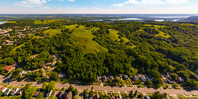
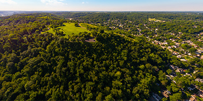
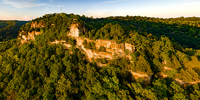 360 degree aerial panorama during sunset at Granddad Bluff. The 600-ft high bluff overlooks the city of La Crosse, Wisconsin. Wisconsin Trails readers voted this the most scenic view in the state.
Equipment: DJI P4P, 24 mm
Categories: La Crosse, Mississippi River, Quadcopter, Wisconsin
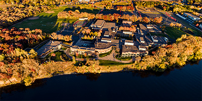
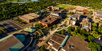
 360 degree aerial panorama over the Coffman Memorial Union at the University of Minnesota.
Equipment: Nikon D70s, Sigma 8mm, PocketWizard Plus
Helicopter: Davis Aviation
Pilot: Mark Boyer
Categories: Mississippi River, University of Minnesota
 360 degree aerial panorama above the University of Wisconsin - La Crosse Campus, in La Crosse, WI.
Equipment: DJI P4P, 24 mm
Categories: La Crosse, Mississippi River, Quadcopter, University of Wisconsin, Wisconsin
 360 degree panorama of the Vulcans making their entry at the St. Paul Winter Carnival.
Equipment: NikonD70, Sigma 8mm, Kaidan QuickPan III
Categories: Mississippi River, Saint Paul, Winter Carnival
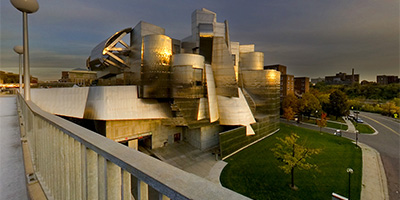 360 degree panorama of the Weisman Art Museum and Mississippi River bridge at sunset.
Equipment: Nikon D70, Sigma 8mm
Categories: Minneapolis, Mississippi River, University of Minnesota
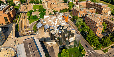 360 degree aerial panorama at Weisman Art Museum on the University of Minnesota Campus along the Mississippi River in Minneapolis, MN. This was planned for World Wide Panorama: Museums but I submitted a Mill City Museum aerial instead.
Equipment: DJI Air2s, 22 mm
Categories: Minneapolis, Mississippi River, University of Minnesota
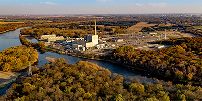 360 degree aerial panorama near the Xcel Monticello Nuclear Generating Plant along the Mississippi River in Monticello, MN
Equipment: DJI Air2s, 22 mm
Categories: Industrial, Mississippi River, Quadcopter, Saint Cloud

Start with the "Featured" category to see an assortment of my most interesting panoramas.