Welcome to BigEyeInTheSky.com
I'm Ed Fink, these are my 360 degree panoramas. I was the first photographer in the world to shoot 360 degree panoramas from a helicopter. Today I'm a FAA licensed drone pilot and shoot most of my aerials with a quadcopter.
In addition to shooting aerial panoramas, I'm also a Google Street View Trusted Photographer in Minneapolis shooting Street View tours inside local businesses.
I publish thousands of 360 degree panoramas and virtual tours to Google Maps, where I currently have over 100 MILLION VIEWS.
Ask me for more information or an estimate for your business!
Facebook - BigEyeInTheSky360
Google Maps - Ed Fink

VISITOR COMMENTS:
"That's the coolest thing on the web."
"You brought tears to my eyes."
"Mind blowing."
"One of the neatest photo sites I've ever seen."
"I'm afraid of heights and when I looked straight down I nearly threw up!"
"I am stunned by the quality and possible applications, nice job."
"That combo of eye-in-the-sky with eyes on the ground is fantastic."
"I sent this to every pilot I know."
"HOW IS THIS EVEN POSSIBLE?!"
"The 360 shots are almost unbelieveable!!!!"
"Oh my gosh Ed - they are just beautiful."
"That aerial panorama over Lake Calhoun is totally awesome"
"FANTASTIC!!!!"
"I've instantly become a fan of your panorama photos!"
"Wow, your panoramas are like nothing I have ever seen before. Very impressive!"
"the absolute best I have seen anywhere."
"ED - I am not surprised by all the comments you have received. The VR is AWESOME!"


Select a panorama category:
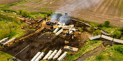
 360 degree aerial panorama above Goose Lake in Albert Lea, MN after a train derailment.
Equipment: DJI P4P, 24 mm
Categories: Industrial, Outstate Minnesota, Quadcopter, Railroads
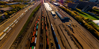
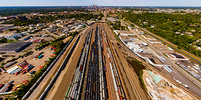 360 degree aerial panorama over the BNSF Midway Railroad Yard in South St. Anthony between Minneapolis and St. Paul.
Equipment: DJI P4P, 24 mm
Categories: Industrial, Minneapolis, Quadcopter, Railroads
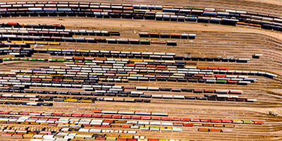 360 degree aerial panorama directly over the BNSF Northtown Railroad Yard in Columbia Heights, just north of Minneapolis.
Equipment: DJI P4P, 24 mm
Categories: Industrial, Minneapolis, Quadcopter, Railroads
 360 degree aerial panorama over the BNSF Bridal Veil Railroad Yard Minneapolis, MN.
Equipment: DJI P4P, 24 mm
Categories: Industrial, Minneapolis, Quadcopter, Railroads
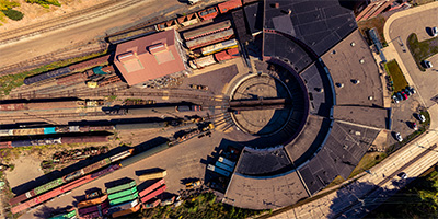 360 degree aerial panorama over the Jackson Street Roundhouse, which is the headquarters for the Minnesota Transportation Museum in St. Paul, MN and a working railroad roundhouse, one of the last of its kind in the country. Built in 1907 to replace an older roundhouse, the site has been used for rail transportation since the first railroad came to Minnesota in the 1860s.
Equipment: DJI P4P, 24 mm
Categories: Industrial, Quadcopter, Railroads, Saint Paul
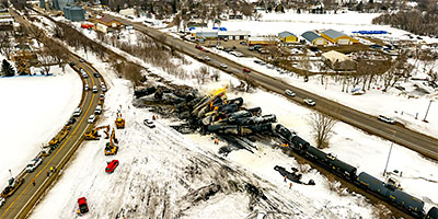
 360 degree aerial panorama from 400' above train derailment site in Raymond, MN.
Equipment: DJI Air2s, 22 mm
Categories: Industrial, Quadcopter, Railroads
 360 degree aerial panorama from 180' above train derailment site in Raymond, MN.
Equipment: DJI Air2s, 22 mm
Categories: Industrial, Quadcopter, Railroads
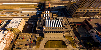 360 degree aerial panorama above the light rail at Union Depot in St. Paul, MN. This was my Spring Equinox 2016 submission to the World Wide Panorama on the theme Travel.
Equipment: DJI P3A, 20 mm
Categories: Quadcopter, Railroads, Saint Paul, Union Depot
 360 degree aerial panorama above Otter Creek in Sibley, Iowa after a train derailment.
Equipment: DJI P4P, 24 mm
Categories: Industrial, Iowa, Quadcopter, Railroads

Start with the "Featured" category to see an assortment of my most interesting panoramas.